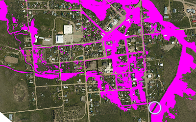
Ekalaka has worked proactively for the last several years to update the floodplain. Great West Engineering secured grant funding to collect LiDAR elevation data. Then the Town leveraged the data to have the U.S. Army Corps of Engineers (USACE) Silver Jackets complete a hydrology and hydraulics study. The Silver Jackets study highlighted the inaccuracies of the old floodplain maps.
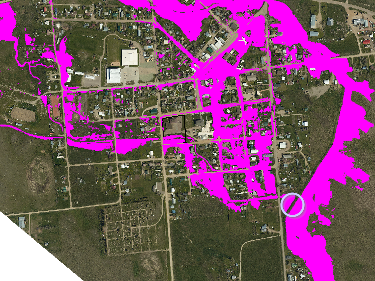
Potential Floodplain Map for Ekalaka Assuming Levee Breach
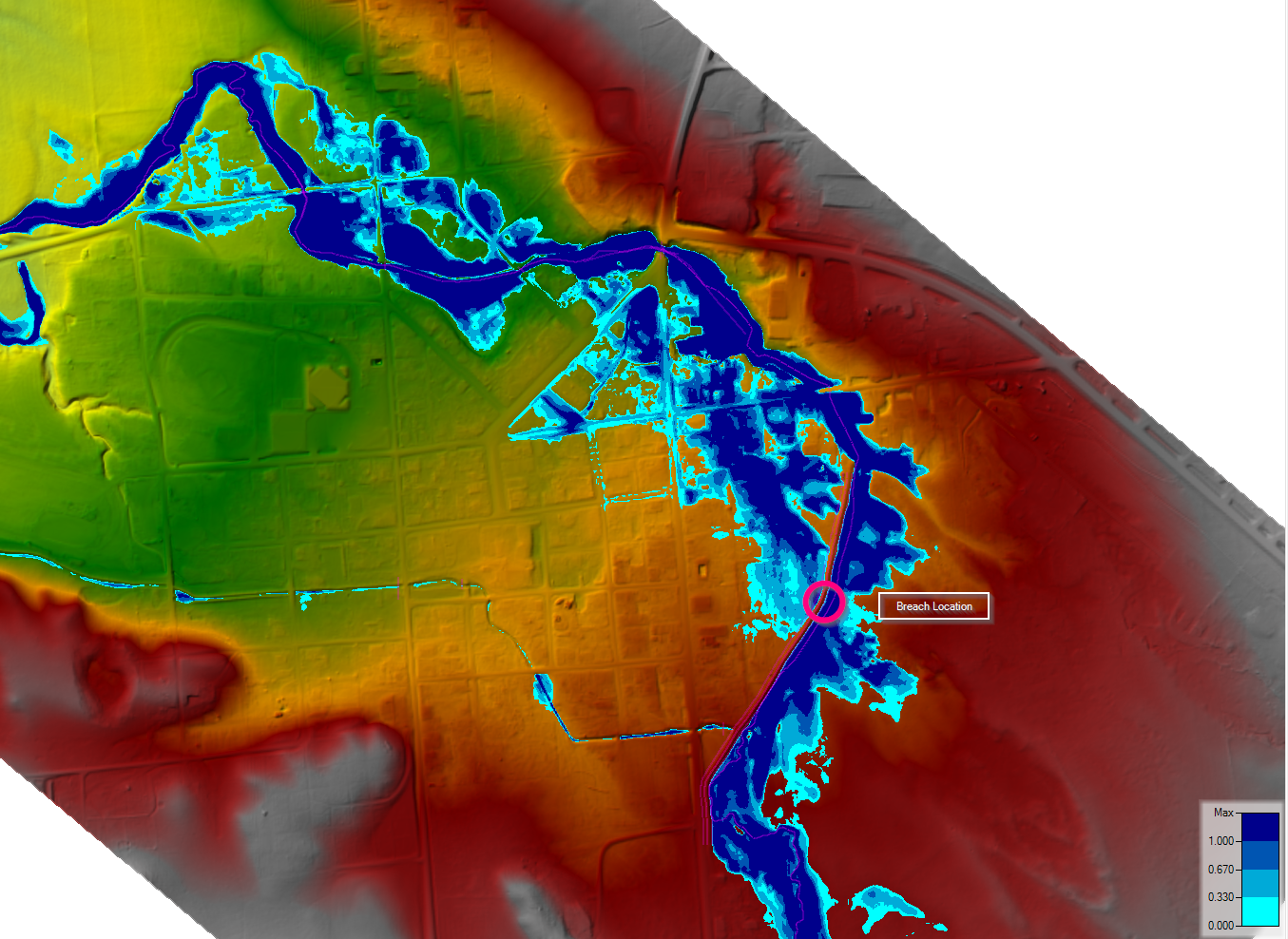
Potential Depth From Levee Breach
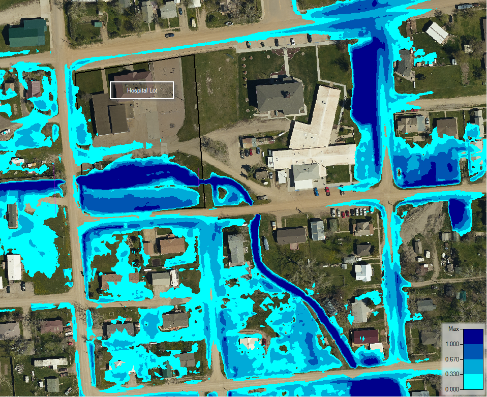
Potential Depth at Hospital During 100 Year Flood Event
In Montana, the Department of Natural Resources and Conservation (DNRC), is responsible for the management of floodplains. The DNRC has indicated they would like to use the Silver Jackets floodplain study to update the floodplain maps for Ekalaka. Updating the maps poses a potentially severe problem for Ekalaka. Why? Because the Town cannot provide documentation to DNRC or FEMA that the “levee” meets federal requirements, so the new floodplain maps will not reflect the protection from the levee. It would be as if the levee doesn’t exist, and the maps will show that much of Ekalaka is in the floodplain. Residents or businesses with federally-backed loans on their property would be required to purchase flood insurance; other lenders may also require flood insurance. Furthermore, development (e.g., new buildings, remodels, etc.) within the floodplain would be severely limited or even disallowed by the enforcement of local floodplain regulations. The economic implications could be drastic for a community that is already struggling to grow.
Great West is currently underway on a study that will evaluate the feasibility of certifying the levee. In order to certify the levee, it must meet a host of federal requirements, ranging from hydraulic adequacy, foundation stability, sufficient right-of-way, and the list goes on. This study will give the Town a solid starting point for determining the next steps for the “levee,” which for Ekalaka, relates directly to the future economic vitality of the community.
Want to talk funding for your next project? Get in touch with our funding experts today!
LATEST NEWS
Beyond the Blueprint: How GIS Enhances Engineering & Planning Solutions
Geographic Information Systems (GIS) have become an essential tool for communities striving to make smarter, data-driven decisions. From infrastructure planning to public engagement, GIS provides a dynamic way to visualize, analyze, and manage data across a wide range...
Yearly ROSE Award Winners
At Great West Engineering, we take pride in recognizing the dedication and hard work of our team. Each year, the Recognition of Special Effort (ROSE) award honors employees who go above and beyond—those who step up, make a difference, and inspire those around them....
Why Transportation Planning Matters
Transportation planning is the collaborative process of evaluating the current state of a transportation network at a local, state, or regional level, identifying future transportation needs, and outlining implementation and funding strategies to align with...